PG&E、高風速に備えてベイエリアの一部で予防的停電を実施へ
 高風速に備えた停電措置
PG&Eは、高い風速と低い相対湿度の組み合わせにより火災リスクが極度に高まっていることを受け、ベイエリアの一部で予防的な大規模停電(PSPS)を実施すると発表しました。
気象サービスは、特に週末の夜から月曜の朝にかけて、時速60マイル(約97km)に達する突風が予想されており、火災が急速に拡大する危険性が警告されています。
停電は日曜日の朝7時頃から始まる予定で、復旧は月曜日の正午から午後4時頃に見込まれています。
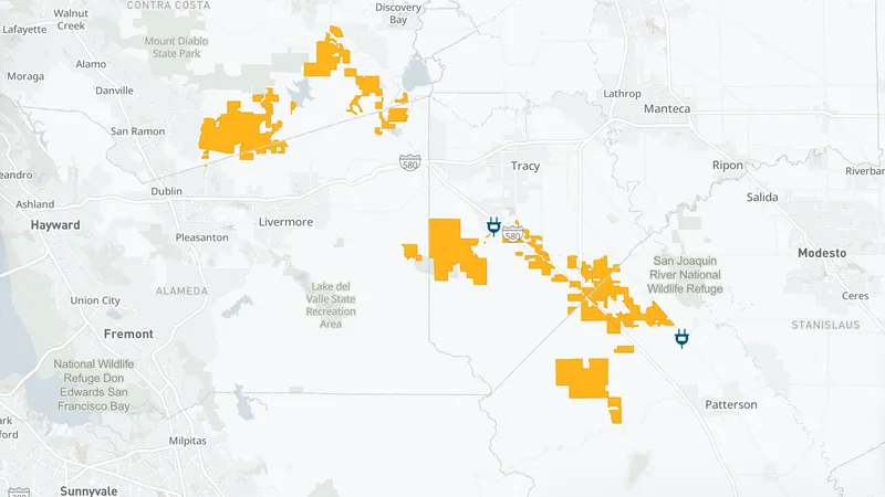
東ベイやノースベイの特定エリアが影響を受ける可能性があり、詳細な停電マップはPG&Eの公式サイトで確認できます。
カリフォルニア州の電力会社PG&Eが、強風による火災リスクの高まりを受け、ベイエリアの一部地域で計画的な停電(PSPS)を実施すると発表しました。これは、火災シーズンにおける同社の最初の大規模な安全対策措置となります。停電は日曜日の朝から始まり、月曜日の午後に復旧が見込まれています。
強風による火災リスクの増大
PG&Eは、予報されている最大60マイル(約97km/h)の突風を前に、東ベイとノースベイの火災リスクの高い地域に対し、予防的な停電を行う計画です。この措置は、強風と低い相対湿度が組み合わさることで、火災が急速に拡大する危険性が高まっているためです。中央バレーやデルタ地域では「レッドフラッグ警告」が継続しており、火災の潜在的な危険性が極めて高い状態が続いています。
具体的な停電対象地域と時間
計画されている停電地域には、ダブリンとブレントウッド間の丘陵地帯や、トレシーとパターソン間の580号線沿いの地域などが含まれます。また、ヴァカヴィルにあるプレザンツ・バレー・ロード沿いの住宅地や、ナパバレーのロバート・ルイス・スティーブンソン州立公園も対象です。停電は日曜日の午前7時頃に始まり、復旧は月曜日の正午から午後4時の間と見られています。住民はPG&Eのサイトで自身の電力状況を確認できます。
気象情報と安全対策の必要性
気象庁のベイエリア事務所は、夜間に風が強まるにつれて、ノースベイ、イーストベイ、サウスベイ、サンタクルーズ郡で中程度の火災天候の危険が予想されています。持続的な風速は15〜30マイル(約24〜48km/h)と見込まれ、稜線部では突風が60マイルに達する可能性があります。火災が発生した場合、その拡大速度は非常に速くなる可能性があるため、電力会社は安全確保を最優先に動いています。
まとめ
今回のPG&EによるPSPSは、気象条件と火災リスクの深刻化に対応するための重要な安全対策です。住民は停電に備え、最新の情報を確認し、安全管理に努める必要があります。
原文の冒頭を表示(英語・3段落のみ)
A map of PG&E shutoffs expected Sunday and Monday due to high winds. PG&E/ScreenshotWith gusting winds on the way, PG&E has declared its first major Public Safety Power Shutoffs of fire season in the Bay Area. Affected areas may start losing power by 7 a.m. Sunday, with an estimated restoration between noon and 4 p.m. Monday.Ahead of forecasted 60 mph gusts, PG&E plans to preemptively cut power to high fire risk areas of the East Bay and North Bay. Planned shutoff areas include the hills between Dublin and Brentwood, areas along the 580 corridor between Tracy and Patterson, the residences along Pleasants Valley Road in Vacaville and Robert Louis Stevenson State Park in Napa Valley. A full map of planned PSPS outages can be found from PG&E.Article continues below this adIn anticipation of fire conditions, Rockville Hills Regional Park in Fairfield also closed Sunday with an expected reopening of Tuesday.“A Red Flag Warning remains in effect across the Central Valley and the Delta, lasting through tomorrow evening due to the combination of gusty winds and low relative humidity leading to critical fire potential,” PG&E said in its Sunday forecast. The National Weather Service’s Bay Area office is anticipating moderate fire weather danger in the North Bay, East Bay, South Bay and Santa Cruz County as winds pick up overnight. Sustained winds of 15 to 30 mph are expected, with gusts of 50 mph possible. On ridgelines, gusts may reach 60 mph. The worst winds are expected to start around 11 p.m. Sunday and last until 11 a.m. Monday. Any fires that start could have “rapid rates of spread,” the weather service said.Stay informed, and entertained.By signing up, you agree to our Terms Of Use and acknowledge that your information will be used as described in our Privacy Policy.To check your power status and sign up for PG&E alerts, visit their site. Article continues below this adMore News
※ 著作権に配慮し、引用は冒頭3段落までです。続きは元記事をご覧ください。